
High-Speed Rail in Eastern Ontario Should Be Beside the 401, 417, 7, or 17 Corridor
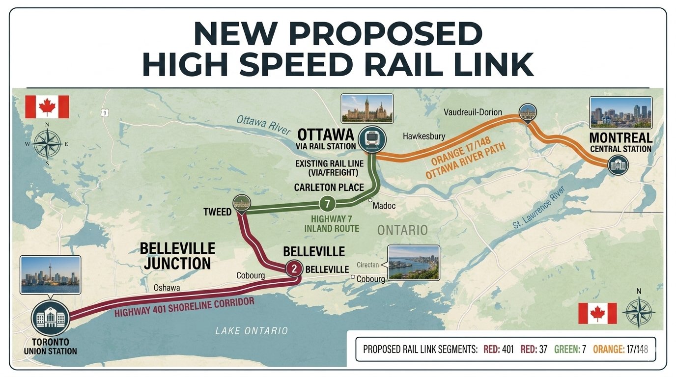


Why carve a brand-new transportation scar across Eastern Ontario when we already have the perfect paths? The Highway 401, 417, 7, and 17 corridors are ready-made for modern infrastructure. Choosing to ignore them in favour of an entirely new right-of-way is not just financially reckless—it is socially disruptive, environmentally counterproductive, and a glaring symptom of a deeper crisis in our public governance.
The ALTO high-speed rail proposal, championed as a transformative leap in Canadian transit, promises to connect major cities with sleek, electrified trains. Academic bodies and economic think tanks, including the C.D. Howe Institute, have long noted that such a project could deliver significant economic and environmental dividends by reducing travel times, boosting productivity, and cutting greenhouse gas emissions.
Let us be completely clear: the ALTO project is fundamentally a good idea. It is a visionary, necessary infrastructure initiative that Canada desperately needs if it hopes to drag its archaic transportation network into the 21st century. However, it currently suffers from a fatal flaw—a severe, systemic lack of public accountability driven by a government and planning apparatus that seem utterly allergic to true transparency and community input. By seeking to forge a completely fresh path through the heart of Eastern Ontario’s countryside without providing any clear public justification, planners are steering a vital project toward public backlash, litigation, and fiscal ruin.
The Case for Co-Location
Transportation planners worldwide have long recognized the immense benefits of "co-location"—the practice of building new infrastructure directly alongside existing rights-of-way. When you build rail lines parallel to established highways, you dramatically simplify the logistics of construction. You minimize fresh environmental disruption, drastically reduce land acquisition costs, and avoid slicing local communities into isolated pieces. It is a common-sense design principle applied successfully across Europe and Asia for decades.
The 401, 417, 7, and 17 highways already cut direct, established paths through Eastern Ontario’s urban and rural landscapes. These corridors possess the physical space, decades of existing environmental baseline data, and a deep public familiarity. Building high-speed rail tracks adjacent to them would be faster to clear, cheaper to secure, and far less contentious. The land has already been altered by human activity; adding tracks next to asphalt preserves the integrity of the surrounding landscape and avoids creating a secondary barrier across the geography of the province.
Mitigating Environmental Damage and Going Underground
The environmental argument for a greenfield route falls apart under close scrutiny. While high-speed rail is meant to reduce emissions long-term, carving out a brand-new path fragments fragile ecosystems, destroys wetlands, and disrupts vital wildlife corridors. The carbon footprint of the heavy construction required to cut through raw wilderness or active farmland completely undermines the project’s short-term green transit goals.
Putting the high-speed rail immediately beside existing highways would drastically mitigate this environmental damage. Co-locating with corridors like Highway 401 or Highway 7 confines the environmental footprint, noise, and visual impact to zones that are already heavily impacted by human activity and vehicular emissions.
Furthermore, where these lines must intersect directly with local municipalities, the tracks could be pushed underground. By tunneling beneath municipal boundaries, the high-speed rail could function almost like a local subway system within those communities. This underground approach completely eliminates the visual barrier and surface noise of a high-speed train, seamlessly integrating national transit with local life without disrupting the fabric of the neighbourhood. It allows Canada to build a green transit future without destroying the natural spaces or urban residential areas we claim to protect.
Rejuvenating Small Downtown Communities
Beyond environmental preservation, tracking these highway corridors and utilizing subway-like underground segments offers a profound socio-economic advantage: the opportunity to breathe new life into small, historically vital downtown communities that have felt bypassed by modern growth. By aligning the tracks with these existing corridors, planners can integrate strategic regional hubs that directly connect into the hearts of rural urban centres.
This project could act as a massive economic engine for towns like Hawkesbury, Cornwall, and Tweed. Instead of merely watching high-speed trains whistle past their horizons on an isolated inland track, these communities could be woven into the fabric of a broader economic network. Station placements near highway junctions—or beneath local transit centers—would allow residents to commute effortlessly to major cities, while drawing tourism, talent, and sustainable investment back into local main streets. It turns a project that risks alienating rural Ontario into an initiative that actively rejuvenates its small-town economies.
The ALTO Route Problem
Yet, the current ALTO plan appears to discard this logic entirely. Instead of utilizing the infrastructure footprints we already possess, it proposes an entirely separate inland corridor. This path would slice directly through tight-knit rural communities, small woodlots, and prime agricultural land.
The National Farmers Union of Ontario has voiced strong opposition to this approach. The organization warns that the project’s current route permanently removes highly productive farmland from active use, disrupting tile drainage systems and splitting generational family operations. A highway splits a region once; a new rail line cuts a second, diagonal wound through fields, making it impossible for modern machinery to navigate the fragmented parcels left behind. Furthermore, agricultural stakeholders argue that the consultation process has been rushed and opaque, leaving rural landowners feeling sidelined by urban-centric planning.
Farmers are not alone in their frustration. Local municipal leaders across Eastern Ontario have questioned why the highway-adjacent options were dismissed so early in the planning phases. Many small-town mayors report that they were never given a clear engineering or financial explanation for the detour. It creates a growing sense of isolation between the communities bearing the burden of construction and the urban commuters reaping the rewards.
An Outdated Playbook: The Critique of Government Opacity
This brings us to the core issue: the government and planning authorities handling the ALTO project are operating under an outdated, paternalistic playbook that treats public disclosure as a compliance chore rather than a democratic necessity. Large infrastructure projects inevitably involve difficult trade-offs, but those choices must be justified to the public with clear, accessible data. In this case, stakeholders have been given severely limited access to route optimization studies, line-item cost comparisons, and localized environmental assessments.
This culture of secrecy is not just frustrating; it is a profound failure of public governance. The governing bodies have consistently cloaked their decision-making processes in bureaucratic jargon, withholding the technical metrics used to disqualify the highway corridors. When public officials refuse to show their math on a project of this scale, it reveals a deeply troubling arrogance—a mindset that assumes the public has no right to understand how its resources are being deployed.
Without total transparency, the state actively invites public suspicion. When a government not used to rigorous accountability hides the data, people naturally wonder if political interests, land speculation, or non-technical factors are driving the choice. While no formal evidence of wrongdoing has been presented, the optics are deeply corrosive to public trust. For a project funded by tax dollars, maintaining that trust is just as critical as laying the physical track.
Furthermore, this institutional opacity completely stifles constructive public debate. By keeping community input at arm's length, the government prevents local experts, farmers, and municipal planners from offering practical solutions—such as the highway alignment or underground town integration. Instead of a collaborative nation-building exercise, the ALTO project is being handled like a top-down decree. If the public believes the route was drawn to benefit wealthy speculators rather than everyday riders and small-town residents, the project will lose its social license long before the first rail spike is driven.
True Economic Costs and International Lessons
From a strict financial standpoint, building an entirely new corridor is guaranteed to drive costs up exponentially. Land acquisition along a new route involves negotiating with hundreds of individual property owners, leading to lengthy legal disputes, costly expropriation battles, and ballooning budgets. Every single kilometre of a new right-of-way is a kilometre that must be bought, cleared, graded, and secured from scratch. If you can avoid those costs by using existing public rights-of-way, you have a fiscal duty to do so.
Other nations offer stark, cautionary tales that Canada would do well to study. In the United States, California’s high-speed rail project ballooned in cost and faced decades of litigation primarily because planners opted for new routes through contested areas rather than sticking strictly to existing transportation corridors. The resulting delays have cost taxpayers billions and turned a visionary transit project into a financial warning. The root cause of California’s failure was a lack of upfront transparency, which allowed political considerations to distort engineering realities until the project became economically unviable.
Conversely, France’s celebrated TGV network frequently parallels major highways when cutting through rural regions. This approach successfully minimized land disputes, sped up construction timelines, and kept the public on board. France demonstrated that when a government presents clear, unvarnished data to its citizens, it can build massive infrastructure quickly and efficiently. Canada has the unique advantage of learning from these international mistakes. We do not need to reinvent infrastructure planning; we just need to look at what works.
A Vital Call for Course Correction
The ALTO high-speed rail project represents a generational opportunity to modernize Canada’s infrastructure and link the Windsor-Quebec City corridor. It is an excellent initiative that deserves to succeed. However, the path the train takes matters just as much as the final destination. Choosing a route that ignores the 401, 417, 7, and 17 highways in favour of a disruptive, opaque new path is a costly mistake that Ontario cannot afford.
The era of deciding the future of rural communities behind closed doors in Ottawa or Queen’s Park must come to an end. It is time for federal planners and provincial leaders to pause, listen to local communities, and embrace the public accountability a project of this magnitude demands. They must immediately release all internal route studies and cost-benefit analyses related to the highway corridors.
By aligning the rail line with our existing highways—and pushing tracks underground within local towns—they can build a project that is economically sound, environmentally responsible, and truly worthy of public trust. Let’s build for the future, but let’s do it with our eyes wide open, with a government that respects the citizens it is elected to serve.

Comments
There are 0 comments on this post