Lake Ontario, Not Lake America: Why Ontario Must Sue Google Over Digital Colonialism
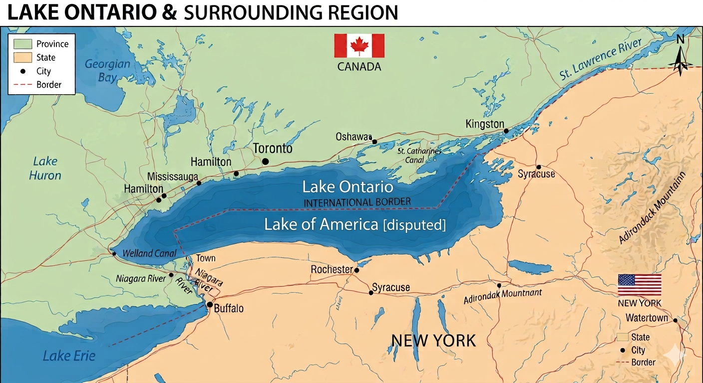
In the age of the smartphone, mapping apps do not merely describe reality—they create it. When millions of people glance at their screens to navigate, plan travel, or check weather patterns, they treat the digital map as an absolute, objective truth. It is this immense psychological and cultural power that makes Google’s recent decision to alter the map of the Great Lakes so dangerous. By extending an American executive order across the international boundary and labelling the Canadian waters of Lake Ontario under a new, unilateral U.S. designation, Google is no longer just hosting data. It is actively spreading state-sponsored misinformation. The Government of Ontario should not stand by and issue toothless diplomatic complaints; it must take Google to court.
As Canadians, our natural instinct when faced with this kind of overreach might be to laugh it off. We may think it is either an absurd joke or just plain insulting—another round of political theatre from Washington to be dismissed with a shake of the head. But we simply cannot let this moment pass by unchallenged. In the quiet, rigorous arena of international law, public silence is not interpreted as polite disagreement; it is interpreted as submission. Failing to challenge this name change in a court of law could, in the eyes of international legal experts, be regarded as a de facto acceptance of the new status quo.
This danger is rooted in the powerful legal doctrines of acquiescence and estoppel—twin pillars of customary international law that dictate how territorial and boundary rights are won or lost over time. Under the doctrine of acquiescence, if a sovereign state fails to offer a timely, formal protest against an open infringement on its rights, international tribunals interpret that silence as implied consent. Passivity creates a binding legal reality. Closely tied to this is estoppel, a principle that prevents a state from later disputing a situation if its own prior conduct, silence, or lack of opposition led others to rely on that state of affairs.
The most famous modern demonstration of this occurred in the landmark International Court of Justice ruling regarding the Temple of Preah Vihear Case. In that dispute between Cambodia and Thailand, the court ruled that because Thailand (then Siam) had failed to protest an erroneous French map that placed the historic temple within Cambodian territory, it had legally acquiesced to that border. Thailand was effectively barred by estoppel from reclaiming the territory decades later. If Canada and Ontario remain passive while the world's most ubiquitous digital cartographer permanently rebrands our waters on global screens, we risk legally compromising our position. Over time, our failure to litigate could be weaponized in international forums as evidence that we slept on our rights, effectively barring us from asserting our original sovereignty. Sovereignty is maintained through active defence, and letting a corporate tech giant redefine our borders on behalf of a foreign power risks setting a catastrophic precedent of acquiescence.
Canadians must recognize that Trump wouldn't have tried this stunt without consulting top lawyers in his administration, and what appears to be an egotistical stunt must be challenged far beyond public relations. This was a calculated legal maneuver. For proof, one only needs to look at the specific rhetoric used to justify the move. In announcing the executive order, Trump pointedly referred to the physical volume and relative deepness of the lake on the American side. This is highly specific bathymetric data—information that the deepest point of Lake Ontario reaches 802 feet within the Rochester Basin on the southern side of the international border. This is data he clearly obtained from strategic advisors, not because he is a geography whiz. By using the lake’s physical depth and volume to claim a dominant stake, Washington's legal advisors are attempting to craft a "substantial connection" argument to legitimize the name change. It must be regarded as tantamount to a malicious neighbour trying to absorb part of your property by quietly moving the survey stakes. If you do not push back immediately against the shifted boundary line, you slowly lose the legal right to your own land.
A History of Cartographic Aggression and Boundary Friction
To understand why the "Lake America" directive is so problematic, one must look at the long history of boundary friction between Canada and the United States. While the two countries boast the longest undefended border in the world, that line was not drawn peacefully, nor has it been free from semantic and territorial combat. Historically, whenever Washington has attempted to wield its cartographic weight unilaterally, it has threatened the delicate legal equilibrium between the two North American neighbours.
The earliest disputes date back to the foundational gaps of the 1783 Treaty of Paris, which established the original boundary lines using vague geographic markers. Because early surveyors lacked precise charts, vast swathes of land became flashpoints for conflict. In the late 1830s, the Aroostook War—a bloodless but highly volatile confrontation over the lumber-rich territories between Maine and New Brunswick—demonstrated how easily ambiguous boundaries could bring both nations to the brink of military conflict. It ultimately required the 1842 Webster–Ashburton Treaty to settle the northeastern border through rigorous bilateral compromise rather than executive fiat.
Similarly, the 1859 Pig War in the San Juan Islands showcased the dangers of unilateral interpretation. Triggered by the ambiguous wording of the 1846 Oregon Treaty, both British-Canadian and American authorities claimed sole jurisdiction over the archipelago. Rather than allowing one side to bully the other into a new status quo, the dispute was referred to an independent international arbiter—Kaiser Wilhelm I of Germany—highlighting that shared geographic disputes require neutral, lawful resolution, not domestic political pressure.
The most poignant historical parallel to today's cartographic overreach is the Alaska boundary dispute of 1903. Following the Klondike Gold Rush, the exact maritime and coastal boundaries between the federal district of Alaska and British Columbia became intensely contested. The United States, led by President Theodore Roosevelt, used aggressive diplomatic pressure and explicit military posturing to enforce its preferred interpretation of the coastline. When a six-member tribunal was assembled to resolve the issue, the British representative sided with the American commissioners to secure U.S. geopolitical favor, effectively outvoting the Canadian members. The resulting loss of territory deeply traumatized the Canadian psyche, serving as an early lesson in how major powers use diplomatic leverage to override geographic fairness. It was this very betrayal that catalyzed Canada’s determination to secure full treaty-making autonomy, culminating in the 1931 Statute of Westminster, which ensured Great Britain could never again trade away Canadian geographic integrity.
Unresolved Waters and Modern Precedents
Even today, five major maritime boundaries remain formally unresolved between Ottawa and Washington. From the salmon-rich waters of the Dixon Entrance in the Pacific Northwest to the energy-dense continental shelf of the Beaufort Sea in the Arctic, both countries maintain distinct, overlapping legal claims. In the Atlantic, the tiny Machias Seal Island remains a "grey zone" where both Canadian and American lobster fishermen operate under conflicting national assumptions of sovereignty.
Crucially, despite these ongoing disagreements, neither country has historically resorted to renaming these shared zones by unilateral executive command. When the United States disputes Canada’s claim that the Northwest Passage constitutes internal Canadian waters, Washington does not unilaterally erase the name from international charts; it registers its legal dissent through established international channels.
The core of the issue is Google’s complicity in erasing Canadian sovereignty. Under well-established principles of international law, no country possesses the extraterritorial authority to unilaterally rename a shared geographic feature outside its own borders. When U.S. federal directives mandated a domestic name change for their portion of the lake, that policy legally hit a brick wall at the maritime border. Yet, on the screens of millions of Canadians, Google chose to blur that line, rendering a foreign political fiction across waters explicitly managed by the Province of Ontario and the Dominion of Canada.
The Onus on Digital Cartography
By superimposing a foreign name onto Ontario's side of the lake, Google is engaging in a severe form of cartographic misinformation. Misinformation is defined not just by outright lies, but by the distortion of verified facts in a way that misleads the public. When a user opens Google Maps standing on the shores of Toronto, Kingston, or Mississauga, and sees their provincial waters rebranded by a Silicon Valley algorithm, they are being fed a falsehood. This distortion erodes public trust, confuses maritime commerce, and soft-launches a narrative that Canadian sovereignty is subordinate to American political whims.
Ontario has a distinct and compelling legal interest to protect. Under the Constitution Act, 1867, provinces hold explicit jurisdiction over their public lands, property rights, and environmental governance. Lake Ontario is a cornerstone of Ontario’s economic, cultural, and ecological identity. The provincial government routinely issues commercial fishing licenses, manages water conservation acts, and regulates shoreline development. Google’s actions directly interfere with these provincial responsibilities by creating jurisdictional confusion. If a commercial shipper, an environmental agency, or a foreign investor looks at the world's primary digital atlas and sees a fractured, legally inaccurate map, Ontario’s institutional clarity is compromised.
A lawsuit by the Government of Ontario would send a necessary shockwave through Silicon Valley. For too long, tech conglomerates have treated international borders as mere inconveniences to be smoothed over by global code. They have hidden behind the defence that they are simply neutral aggregators of geographic data. But when Google chooses to validate one nation's unilateral overreach while overwriting another nation's established legal boundaries, it abandons neutrality. It becomes a political actor.
Suing Google is not merely about defending the name of a body of water that has been known as Ontario for centuries, rooted deeply in Indigenous history long before modern borders existed. It is about establishing a legal precedent for the digital age: tech companies cannot rewrite the physical geography of sovereign states to appease foreign governments. If Google refuses to respect international law and insists on publishing map data that misleads the public, Ontario must use the power of the courts to protect its borders from digital erasure.

Comments
There are 0 comments on this post